Mineral Hill Overview
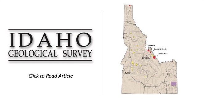
The Mineral Hill Rare Earth Elements Project is comprised of 109 unpatented lode mining claims covering an area of approximately 830 hectares (2,100 acres). This Project is located within the Mineral Hill Mining District, approximately 48 kilometers (30 miles) northwest of Salmon, Idaho. In Idaho, most of the lode REE occurrences lie along a northwest trending line that extends from Lemhi Pass, through Diamond Creek, to the Mineral Hill district, before crossing the Idaho-Montana state line. This lineament stretches more than 50 miles across central Idaho. The Mineral Hill Project is on this trend and is the next best REE mineralization northwest of IDR’s Diamond Creek Project.
The Mineral Hill district was historically prospected in the early 1900’s for gold and copper. Rare earth element (REE) mineralization was first discovered in the early 1950’s. Studies conducted by A. T. Abbott (1954) and A. L. Anderson (1958) from the Idaho Geological Survey, and E. P. Kaiser (1956) with the USGS, pioneered recognition of these REE occurrences. Abbott reported cutting a 2.5-foot sample across the Roberts Lode which returned 21.5 % combined rare earth oxides and thoria.
REE Mineralization
The Mineral Hill Project contains three of the eight known carbonatite occurrences within the Mineral Hill District. The unusual carbonatite seam and intrusive plug occurring on the Mineral Hill property are characterized by an exceptional REE concentration. REEs like; neodymium, praseodymium and samarium occur on the property in abundance. Similarly, as with IDR’s Diamond Creek project, REE’s are not the only valuable commodities; gold and niobium may also be profitable by-products. Recently collected samples at the Mineral Hill property, by company geologists, show assays with gold values up to 8.8 grams per ton (0.25 ounce per ton) and niobium as high as 0.50%.

Mineral Hill’s Potential
The Mineral Hill Project contains three of the eight known carbonatite occurrences within the Mineral Hill District. The first carbonatite can be found in a northwest-trending seam which measures approximately 400 meters (1,300 feet) long and 90 meters (300 feet) wide; the second occurrence occurs as a small carbonatite plug, measuring about 200 meters in diameter. The REE commercial potential of the Mineral Hill prospect, and the other Mineral Hill district carbonatites, was recognized in the early 1950’s, however there was no demand for REE’s then; but that has recently changed due to its new uses in high-technology, defense, and clean renewable energy. The carbonatite deposits found at the Mineral Hill REE Project most likely occur from deep seated systems, with their geochemistry suggesting these roots are tapped into alkaline intrusive bodies; which significantly boosts the potential for a REE deposit to be found at depth in the Mineral Hill area.